Online map of Ruka Bike Park routes
The summer online slope map shows the Ruka Bike Park routes. If the website shows the winter slope map, click the sun symbol on the top right side of the map.

The summer online slope map shows the Ruka Bike Park routes. If the website shows the winter slope map, click the sun symbol on the top right side of the map.
The lift-accessible downhill biking trails at Ruka Bike Park are divided into two categories: flow and technical. The trails are listed from easiest to most difficult, allowing you to choose routes that match your skill level and progress gradually toward more challenging riding experiences.
All trail starting points are marked with Ruka Bike Park signs and bike park rules. Trail difficulty levels (green, blue, red & black) are indicated by the color of the trail sign at the starting point. Sections requiring special attention (e.g. intersections, drops, etc.) are marked on the terrain with signs. Familiarize yourself with the trails carefully at first and always follow the bike park rules while riding in the bike park.
All trails are inspected daily by staff to ensure safety. However, if you notice anything unusual or dangerous on the trails, please report it immediately to the lift staff, for example. Remember that everyone has a duty to help in the event of an accident. Report all accidents to staff immediately.
During the summer, there are many reindeer roaming the area, and riders should take them into account to avoid collisions while riding.
Each trail description includes specific risks associated with that trail and the solutions implemented to reduce those risks.
Mainly machine-built trails approximately 1–2 meters wide, with mostly smooth trail surfaces. They include rollers, shaped features, berms, and jumps that can also be ridden safely without jumping. On green and blue trails, riding can be stopped safely at any point and the rider can walk down if necessary. Staff access to these trails is also easy when needed. On the lower section of Kelo Flow, the terrain becomes steep in places, meaning it is not always possible to stop riding safely.
Family Park is located right next to Ruka Valley. A covered conveyor lift operates on the slope, easily transporting younger riders halfway up the Family Park area. The easiest trail begins from the top of the conveyor lift and winds back down to the bottom. The trail includes low-threshold wooden obstacles and bermed turns. This is an excellent choice for beginners.
Two optional practice tracks have been built on the Mini Ruka slope: one designed to meet green trail requirements and the other blue trail requirements. In addition, there is a small practice jump line with drops and jumps of varying sizes.
This trail is an excellent choice for beginner riders. The Kuru Flow trail starts near the gondola mid-station in front of the Base restaurant and descends toward Ruka Village. The route shares its starting section with the Vuosseli Flow trail, but the trails separate after a few turns. To stay on Kuru Flow, choose the right-hand lane at the junction. The intersection is clearly marked.
The lower section of the trail has been renewed and now runs along the lower section of the FIS slope, ending near the Talvijärvi lift exit, from where it is a short distance to the Village Express lift for another lap.
The trail features berms, rollers, and easy ride-over jumps and trail features.
This trail shares the same start as the Kuru trail near the Base restaurant. After a few hundred meters, it separates from Kuru and continues through multiple turns toward the eastern side of Ruka, ending near the lower station of the Kulma(O) lift. The intersection is marked clearly.
The trail is well suited for beginners and can even be ridden on a basic city bike.
At the end of the trail, riders can easily transfer to the gondola if the Kulma lift is not operating or if the T-bar lift still feels too challenging. The trail is one of the longest in the park and offers a pleasantly gentle descent toward East Ruka. Speed can easily be adjusted according to skill level.
The trail includes berms, rollers, and other ride-over features. In the lower section there is also a small wooden platform/jump, which can easily be bypassed.
The trail crosses a lift line that may be operating. Please use caution when crossing the uphill line.
Easy Way Down 3 starts near the top station of the Village Express lift. Riders can connect to Vuosseli Flow (right) or Kuru 1 (via a short service road section and left turn) after the large wooden bridge on the trail.
The trail features berms, rollers, wooden structures, and other ride-over jumps and trail features.
This trail starts near the Kelo lift exit and ends by joining Vuosseli Flow on the East Ruka side, with convenient access to the Kulma(O) lift or gondola. The start can be found by following signs from the Village Express top station. The trail shares its beginning with Masto Flow before splitting off after a short distance.
The route follows the Ahonlaita slope, mainly on the right side, briefly entering the Masto slope area. It is best suited for riders with some downhill biking experience or riders familiar with Ruka Bike Park’s green trails.
The trail contains berms, some of them larger than on green trails, though still manageable at lower speeds. It also includes rollers and ride-over or bypassable jumps/features.
Masto Flow shares its starting section with Ahonlaita Flow near the Kulma lift unloading area and ends by joining Vuosseli Flow or alternatively reaching the Masto rest hut. Both options provide convenient access to the Kulma(O) lift or gondola.
The trail winds through the forests of the Masto slope area, offering a long descent with stream crossings and sections passing close to a forest pond.
The trail includes berms, rollers, and ride-over or bypassable jumps/features. Features are larger than those on green trails, but all sections can be ridden with wheels on the ground except for the right side of a wooden platform in the middle section, which contains a drop. The left side is rollable.
Saarua Flow begins near the gondola mid-station and descends toward the gondola base station at Ruka Valley. It is best suited for riders with some downhill biking experience.
The trail crosses service roads several times and passes near a disc golf course.
It includes berms, rollers of different sizes, roots, rocks, and several jumps that can either be rolled or bypassed. The riding surface is more natural than previous trails, and some sections are steeper.
Kelo 9 starts near the turnaround wheel of the Kelo(E) lift and descends along both sides of the Kelo slope, ending behind the Riipinen Game Restaurant, with easy access back to the Village Express lift.
The trail is intended for experienced riders seeking a fast and flowing descent. It begins as a wide, fast machine-built section but becomes steeper, narrower, and more technical after the wooden bridges in the middle section. All features can still be rolled if desired.
The lower section becomes steep in places, meaning it is not always possible to stop safely. Riders are advised to inspect the trail on foot first if necessary.
These are natural, narrower, and more technically demanding trails, often hand-built following the natural terrain contours and using varying surface materials. Trails include rocks, roots, jumps, and other demanding features. Some jumps can be bypassed. Riders are advised to familiarize themselves gradually and increase speed progressively.
On blue technical trails, riding can safely be stopped at any point. On red and black trails there are sections where stopping safely may not always be possible. Riders should inspect trails carefully and on foot when necessary. Access for staff and emergency assistance may take time in steep sections.
Ahonlaita Tech starts beside the Village Express lift and shares the beginning with Easy Way Down. The trail ends near the lower station of the Kulma lift.
The trail descends through forests on both sides of the Ahonlaita slope. It was previously used in the Funduro Cup at Ruka and is an excellent introduction to more technical enduro-style riding.
The trail is narrow and natural, featuring rocks, roots, and fast forest singletrack. The lower section was renewed for the 2025 season and now includes steeper terrain. It is ideal for recreational riders looking to improve technical skills.
Masto Tech begins along the service road leading toward the Kelo slope. The easiest way to find it is by following the start of Masto Flow and continuing along the first service road for approximately 75 meters until the trail turns left.
The fast trail was part of the Funduro Cup at Ruka and is a favorite enduro trail among experienced riders. The lower section was rerouted in summer 2025 to provide a longer enduro-style segment.
The trail features varied terrain from rocky upper sections to lower singletrack sections demanding endurance and control. Rocks, roots, and natural trail sections are common.
Kelo Tech starts near the Village Express unloading area on the front slope side and descends toward the Kulma lift turnaround. The trail runs through the forest beside the Kelo slope before entering the steep lower section of the slope itself.
Kelo Tech is a full-scale downhill race trail where Finnish Championship titles and cup podiums have been contested. The trail is divided into three sectors:
Open grassland, rock slabs, tundra trail, and fast riding with several berms.
The fastest section of the trail, featuring jumps, drops, rocks, roots, and a bypassable gap jump.
The most technical section, with steep terrain, roots, rocks, and a large wooden platform drop onto the Kelo slope. Easier alternative lines are available.
The trail includes gap jumps, rock gardens, roots, cliffs, wooden obstacles, and drops. It is intended for highly experienced riders with advanced jumping, dropping, and bike-handling skills.
The Kaltiolampi skill track is a 0.3-kilometer long training track for all levels, which runs around Kaltiolampi. The route has easy wooden training elements on even ground.
![]()
The pump track is located next to the Bistro restaurant, in the immediate vicinity of the Family Park. The pump track is paved with asphalt and includes bumps as well as tilted bends in a track-like shape. It can be pulled in any direction, in any order or by any means! The pump track is suitable for small bikes, skateboards or scooters.
![]()
Pessari 10 leaves the Ruka Valley and is 1.5 kilometers long. The route is technically a bit more demanding, including demanding climbs.
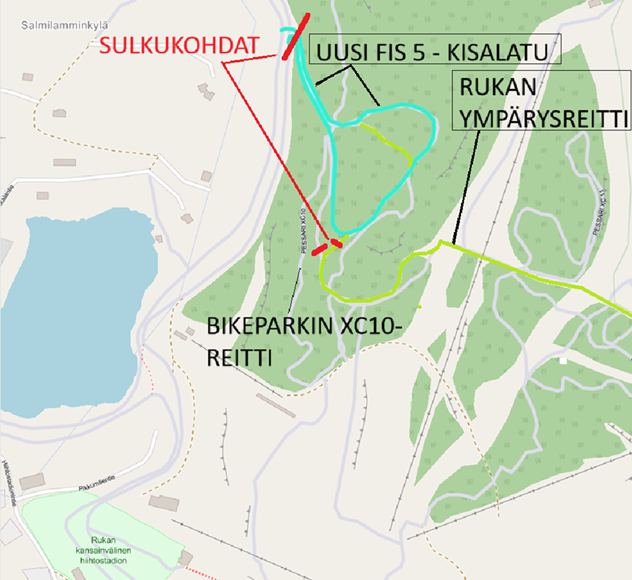
Construction of a new section of the FIS 5 race trail along the Ruka circular route began on 8 June 2026. Due to the works, hiking and mountain biking routes in the area will be temporarily closed at times throughout the summer, with disruptions expected until late September. As heavy machinery will be operating in the area, visitors are asked to follow all signage and be prepared for possible route closures. For more information, please see the City of Kuusamo’s official notice.
Pessari 11 is a more technically challenging 0.9-kilometer route that starts from the Ruka Valley. The route includes demanding climbs.
![]()
Pessari 12 is a technically easy 0.6-kilometer long route suitable for drivers of all levels. The route has easy ascents and descents and starts from the Ruka Valley.
![]()
Technically easy The Pessari 13 is a 0.5-kilometer long route that includes easy ascents and descents and is suitable for drivers of all levels. The route starts from the Ruka Valley.
![]()
Ruka Circle Route is a technically easy 8.6-kilometer long route that includes some physically strenuous ascents as well as varying bottoms. The route leaves from the Ruka Village.
Ruka Top Trail is an easy 3.9-kilometer circular route from the Juhannuskallio car park. The route has one demanding ascent to the top of Ruka and is partly the same route as the Ruka route.
![]()
The circular route along the gravel road and the chewing track is 5.8 kilometers long and starts from the Juhannuskallio car park. Along the route, some duckboards have been built over the wettest points.
The Kivilammi circular route is an easy and flat 5.1 km long circular route, which is perfect for families! The start of the route is from the Juhannuskallio car park.
![]()
Kalliolampi XC is an easy 3.9-kilometer circular route that runs along a toboggan run and ski trails from the Juhannuskallio car park. The route has one demanding ascent to the Ruka Village.
![]()
The technically easy Koervaara XC route starts from Tapiolanranta in Ruka and ends at the Youth and Nature Tourism Center in Oivanki. The route is a whopping 43 kilometers long and includes duckboards that adds demands.